In this blog post I’ll give a quick introduction to OpenStreetMap, and how I started contributing back in 2021. I would still consider myself a beginner or at least not a power-contributor, so I hope that this guide will be the easy to follow for everyone.
Note: The app I’m using here is only available for Android. But even if you use iOS this is still a nice article imho. :)
What is OpenStreetMap again?
OpenStreetMap is comparable to Wikipedia in its goals and methods. It aims to be a crowd-sourced map of the entire world, open and free to use. If you have ever used Apple Maps, played Microsoft Flight simulator 1, or checked out a point of interest on Facebook, you probably interacted with data from OpenStreetMap. Data that more than 10 million mostly volunteers have contributed over the last 19 years.
The reason why these huge companies can and are relying on OpenStreetMap for at least parts of their world-mapping needs is that the data is licensed under the Open Data Commons Open Database License (ODbL). In short, you are free to share and adapt the database, and build products/projects on it, as long as you attribute the contributors, share your adopted version under the same license, and always (also) offer a version of the database without DRM, if you are distributing it.
Ok, why should I contribute?
Without OpenStreetMap, it would be hard or even impossible to create any small projects that need a relatively detailed map of the world.
You can see this from a capitalist/market perspective: It allows small companies/cooperatives to create great new products, which could never see the light of day without OpenStreetMap breaking down the very high barrier to entry in this market - the barrier of having access to map data. This is especially important, as the big tech companies try to hold down, copy, or simply buy any potential future competitors.
From the societal perspective, it also helps small, non-commercial projects, to cross the same barrier. Projects like OpenTracks, with which you can track your runs, cycle tours, kayak trips or similar activities, without the invasive metric-slurping analytics packages that many other sport trackers come with. There are many other applications, from special use-case routing apps to research and education.
But what it opened my eyes for, is navigation for people with disabilities. Traffic lights, bus stops, and pedestrian crossing all have features that ideally help visually impaired people to use and navigate them, like buzzers and tactile pavings. Of course, I noticed them before here and there, but when mapping in your local area, you really notice where they are, and, maybe more importantly, where they are missing.
And then there is the routing information for wheelchair users or other people who struggle with steps/stairs. Ramps next to steps, the height of curbs, general wheelchair accessibility of buildings: All of these things can and should be mapped.
Still not convinced…
Sure, these are all high and lofty reasons to contribute, but what about me? What do I get out of it?
Fun. Contributing to OpenStreetMap is really fun.
You’ll get outside, you will see your home with different eyes, and you might even get to know hot singles cool mappers in your area.
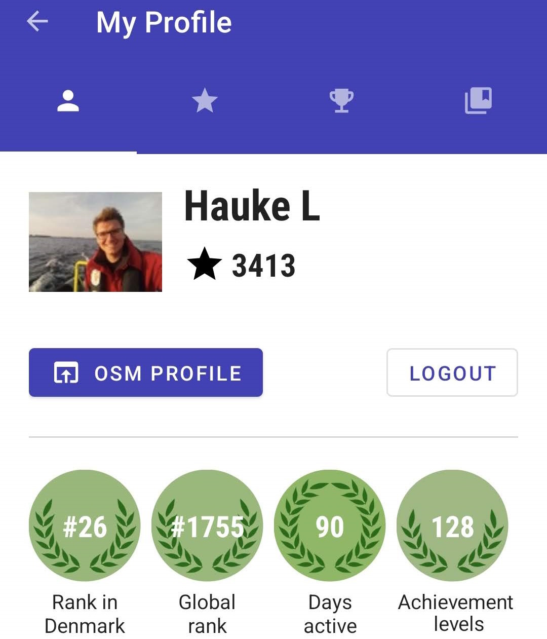
You will see your edit count go up, see what kind of tasks you solved and where, and get sparkly awards like “Lifesaver” 🧑🚒, “Cyclist” 🚴, or “Postman” 📯.
On top of that, you will get these little moments of pride whenever you’ll see the “Copyright © OpenStreetMap Contributors”. And you do see it a lot: On the in-flight entertainment screen, your local bus display, or a random website. I’m doing my part! (even if it’s just a tiny tiny contribution)
Alright, so how do I do this?
1. Download StreetComplete
The easiest way to get started is to download the app StreetComplete on Android.
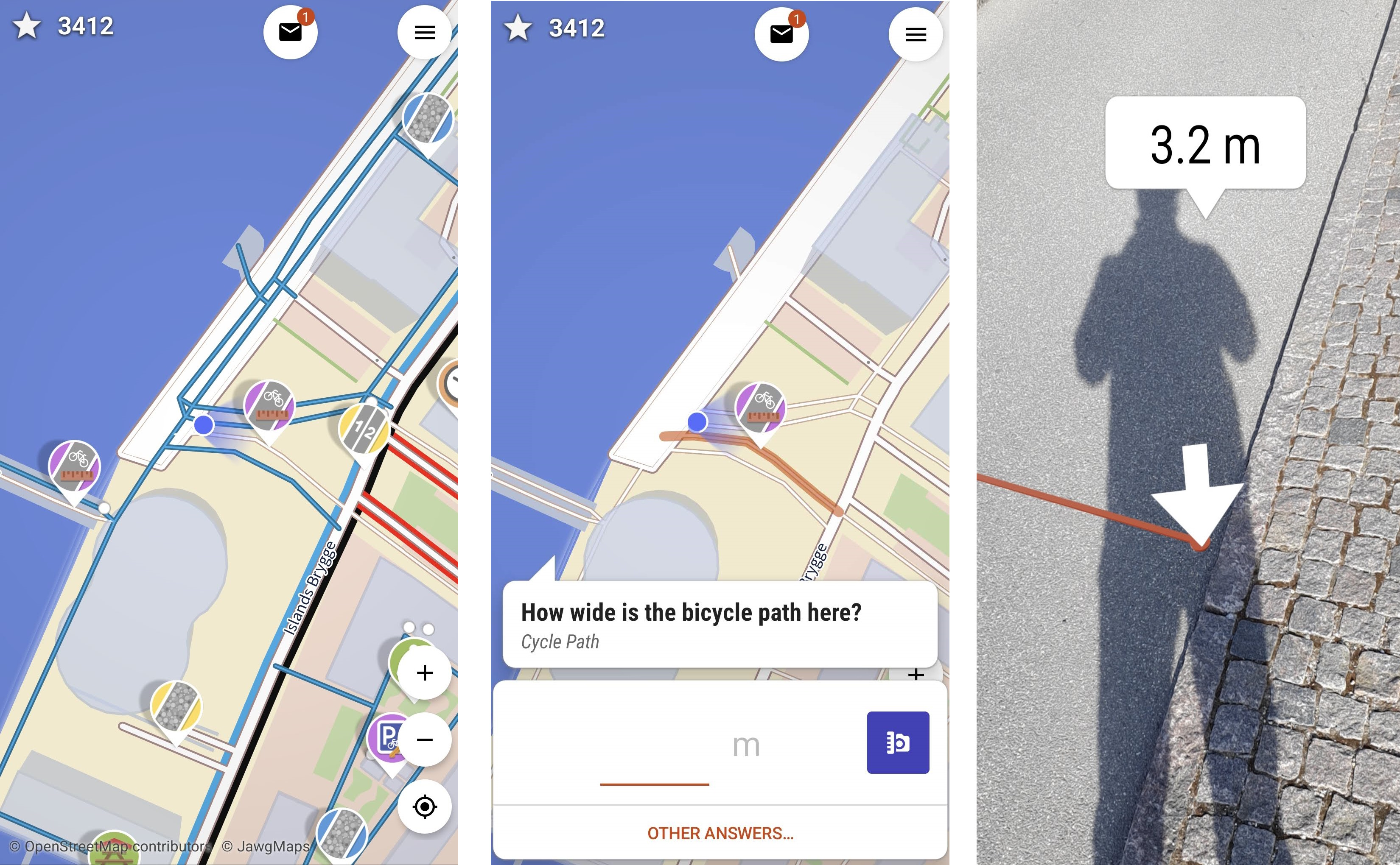
You will see the map of your local area with little location pins on it. Each pin comes with an icon, that symbolizes the type of the “quest”. Each quest is basically a question about a real-world something - from small things like post boxes and traffic lights (“nodes” in the OSM database), to long things like bicycle paths and streets (“ways”), to large things like entire parking lots and parks (“areas”).
Each of these things can have different attributes in the OpenStreetMap database. A pedestrian path can for example have the attribute “lit”, which can be set to “yes” or “no”, to indicate whether there is lighting at night. 2
If this information is missing, you come in: Clicking on the pin, you will be asked a question - like in this example: “Is this way lit”? Then it is as simple as clicking on yes or no, depending on whether you see lanterns, and that’s it.
2. Create an openstreetmap.org account
Now, at this moment the information you just added is stored locally on your phone. To be able to contribute it to OpenStreetMap, you need an account. In StreetComplete, simply click on the Hamburger menu in the top right (☰), tap on “Profile” and “Login”. You will be redirected to the official openstreetmap.org website, where you can either create a new account or log in with a number of different identity providers.
Note: Keep in mind that this account can likely be connected to your actual identity by a motivated actor. When contributing using StreetComplete you are inevitably publishing your (past) locations, and if you do that over some time, patterns might emerge (your home, your workplace, your school, your travels) that could be used to figure out who you are.
Afterwards your StreetComplete app will ask for your permission to act in your name, to be able to upload your answers, which you have to grant.
3. That’s it
Really. That’s it. (Article continues below)

Now get out there (#dataMotion), and solve fun quests like:
How many bikes can be parked here? What is the width of this street? (Good: Augmented Reality! - Bad: Might get run over.) Do these steps have a handrail? Are these opening hours of this restaurant still correct? What type of building is this?
It’s like Pokémon Go, but for the greater good! (and, of course, for Pokémon Go, which uses OpenStreetMap data, too)
And beyond…
StreetComplete was my entry into the world of OpenStreetMap. I knew about the project for a long time but always thought that it was a complicated beast, guarded by strict administrators that would thoroughly review and probably reject my fumbled contributions.
But with StreetComplete you really can’t do anything wrong, as long as you can reliably tell if a picnic table is protected from rain or not.
And over time I started to contribute to OpenStreetMap using other methods, too: The so-called iD editor, which is the default web editor on openstreetmap.org, has a slightly higher learning curve but still comes with helpful hints and auto-completions.
Let’s say you are using StreetComplete, and are looking forward to entering information about some post box, just to find out that it is not mapped yet?! Inconceivable! That’s when you open iD editor, complete the short tutorial in 5 minutes, just to add the missing something, and suddenly they got you. I might go over my favorite ways of contributing other than StreetComplete in another blog post.
Have fun out there mapping!
-
This also lead to the hilarious case of the 212-story high shed in the flight simulators version of Melbourne; a sight which caused simulation-pilots from all over the world to flock there to circle this point of interest. This had already been fixed in OpenStreetMap, but Microsoft had exported their data ahead of the fix. (Source) ↩︎
-
Side note: Being a tall, optimistic dude, I didn’t really think about this before, but it could really come in handy to be able to tell your phone “Please guide me home, on ways that are lit if possible” at night. ↩︎